Navionics+ Charting
Comes preloaded with coastal and inland maps, Auto Guidance+ technology, and daily updates, offering the best routes and bottom details.
$0.00
Your cart is empty
Join our community for exclusive offers and updates.
No, thank you. I'll pay full price.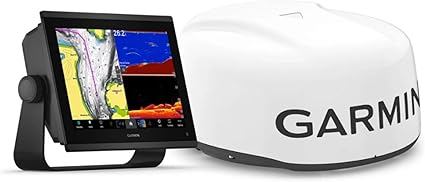
OURBIZ-US Shop
Command the water with a high-resolution IPS touchscreen and detect obstacles or weather up to 36 nautical miles.

Elevate your boat's safety and intelligence with this premium Garmin package. At the heart of the system is the GPSMAP 1243xsv, a 12-inch chartplotter with a high-definition IPS touchscreen, visible even with polarized sunglasses. Equipped with an ultra-fast processor, it redraws maps and sonar data instantly, integrating seamlessly with your boat's ecosystem.
This bundle includes the powerful GMR 18 HD3 Dome Radar. Unlike basic radars, this 4kW model offers superior target definition, allowing you to see birds, buoys, and other vessels with clarity, day or night. Additionally, with preloaded Garmin Navionics+ mapping and integrated sonar (ClearVü/SideVü), you'll have complete control over what's happening above and below the surface.
Navigate confidently in fog or rain. This 18" 4kW radar offers dynamic scanning, auto gain, and MARPA tracking, detecting traffic and weather from 20 meters to 36 nautical miles.
WXGA resolution (1280 x 800). IPS technology offers vibrant colors and wider viewing angles than traditional LCD screens, ensuring perfect visibility from any point on the helm.
The chartplotter has integrated 1kW CHIRP, ClearVü, and SideVü sonar. Connect a transducer (sold separately) to see fish and structures with near-photographic quality and high-contrast color palettes.
Advanced features designed for sport fishing, cruising, and sailing.
Comes preloaded with coastal and inland maps, Auto Guidance+ technology, and daily updates, offering the best routes and bottom details.
Integrated J1939 and NMEA 2000 ports. Easily connect engines, autopilots, Fusion-Link systems, and sensors without additional black boxes.
The radar automatically adjusts levels based on the environment, filtering out sea clutter and rain noise so you only see the real targets that matter.
If you sail, enjoy laylines, enhanced wind rose, heading and course over ground (COG) lines to optimize your navigation.
| Chartplotter | Garmin GPSMAP 1243xsv |
| Display | 12.1" IPS Touch (1280 x 800) |
| Radar | GMR 18 HD3 (4kW, 18") |
| Integrated Sonar | 1 kW CHIRP, ClearVü and SideVü |
| Maps | Garmin Navionics+ |
| Connectivity | NMEA 2000, Ethernet, Wi-Fi, ANT+ |
| Water Rating | IPX7 |
| GPS Antenna | Internal 10 Hz |
| Box Contents | Chartplotter, Radar, Network/Power Cables, Mount |
Yes, the GMR 18 HD3 radar dome includes a 15-meter (49-foot) power cable and a 15-meter Garmin network cable to connect directly to the chartplotter.
Yes, the GPSMAP 1243xsv is fully compatible with Panoptix and LiveScope live sonar technology (requires Panoptix module and transducer sold separately).
Yes, the 'Radar Overlay' function allows you to superimpose the radar image directly onto the navigation chart. For best results and accuracy with this function, it is recommended to install a heading sensor or magnetic compass.